


Sydney has recorded its coldest day of 2025, with a polar airmass, strong winds and showers sending temperatures tumbling across Australia’s southeast.
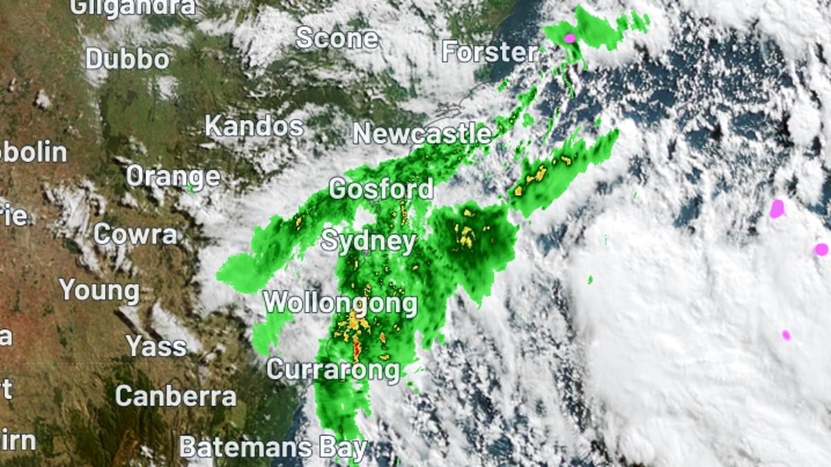
Temperatures in the Harbour City had reached just 10C by 9am on Wednesday, with a ‘feels like’ temperature of a frigid 5.3C.
Even colder weather was recorded across Greater Sydney, with Mount Boyce in the Blue Mountains dropping to 2.5C at 9:30am, which felt like –2.9C due to icy winds.
Light snow was reported on parts of the Blue Mountains, with more expected across the alpine region this long weekend.
Terrey Hills on Sydney’s Northern Beaches reached just 8.7C at 9:30am, with temperatures feeling like 4.8C.
Temperatures peaked at a maximum of 15C, two degrees below the city’s June average.
Sydneysiders are in for a slight reprieve on Thursday, with temperatures to hit 17C.
But on Friday, temperatures will plunge once again to a chilly minimum of 6C.


Warmer weather is expected on Thursday, but will dip again on Friday (stock)


Temperatures in Sydney struggled to get over 10C at 9am on Wednesday, with a ‘feels like’ temperature of a frigid 5.3C (pictured is a Weatherzone map)
On the NSW coastline, a powerful low pressure system over the Tasman Sea is generating big swells along with powerful wind gusts and showers.
A hazardous surf warning is in place for the Byron Bay Coast, Coffs Coast, Macquarie Coast, Hunter Coast, Sydney Coast and Illawarra Coast, with gale or strong wind warnings for the entire NSW coastline.
Further west, Perth recorded its wettest day since July last year.
Perth picked up 47.6mm of rain during the 48 hours ending at 9am AWST on Wednesday, with 33.2mm falling in the last 24 hours.
Bickley, southwest of Perth’s CBD, recorded 41mm in the 24 hours to 9am on Wednesday – the suburb’s heaviest daily rainfall in nine months.
The wet weather is set to ease on Thursday and Friday, however a cold front could impact the state’s southwest from early next week.


Perth saw its wettest day in a year, with 47mm of rain falling across Tuesday and Wednesday
Sydney
Friday: Partly cloudy. Min 6 Max 18
Saturday: Mostly sunny. Min 10 Max 19
Sunday. Partly cloudy. Min 9 Max 18
Monday. Partly cloudy. Min 7 Max 16
Melbourne
Friday: Showers increasing. Min 8 Max 14
Saturday: Showers increasing. Min 9 Max 15
Sunday: Showers. Min 7 Max 13
Monday: Showers. Min 6 Max 14

Sydneysiders will be heading into a cool King’s Birthday long weekend (stock)


A low pressure system in the Tasman sea is causing strong waves across the east coast
Hobart
Friday: Shower or two. Min 4 Max 14
Saturday: Shower or two. Min 7 Max 14
Sunday. Showers increasing. Min 5 Max 14
Monday. Showers. Min 9 Max 14
Adelaide
Friday: Showers. Min 8 Max 17
Saturday: Showers. Min 9 Max 16
Sunday: Showers. Min 7 Max 13
Monday: Showers. Min 6 Max 15
Canberra
Friday: Morning frost, cloudy. Min -2 Max 13
Saturday: Shower or two. Min 2 Max 12
Sunday: Showers. Min 2 Max 10
Monday: Showers. Min 0 Max 9

The Blue Mountains in Greater Sydney recorded -2.9C on Wednesday morning (stock)
Darwin
Friday: Mostly sunny. Min 21 Max 32
Saturday: Sunny. Min 20 Max 31
Sunday: Mostly sunny. Min 22 Max 31
Monday: Mostly sunny. Min 20. Max 31
Brisbane
Friday: Sunny. Min 9 Max 23
Saturday: Partly cloudy. Min 12 Max 24
Sunday: Mostly sunny. Min 11 Max 23
Perth
Friday: Partly cloudy. Min 8 Max 19
Saturday: Sunny. Min 7 Max 20
Sunday: Sunny. Min 7 Max 21


